
Start: Tundra Lodge & RV Park, Alaska Highway, Tok, Alaska
Finish: Six Mile River Resort, 3015 Tagish Road, Tagish, YT Y0B 1T0, Canada
Distance Traveled: 456 miles
Time Traveled: 9h 45m
Total Distance: 1145 Miles
Total Time: 26h 20m

Biscione wrote:I mean, Renaldo Jimenez, could you ask for a more world class pay driver? Who even is Alexey Buyvolov, amirite?

Rob Dylan wrote:Mercedes paying homage to the other W12 chassis by breaking down 30 minutes in

An old and now slightly mad Australian man wrote:Day 3:
I've decided to start keeping a journal, writing down my experiences. There's bathplug all else to do.
It's bathplugging cold. And boring. And there's no one to talk to. Not that I need anyone.
I've decided to start tailgating that Mike bloke. It's more interesting, especially when he freaks out as a result.
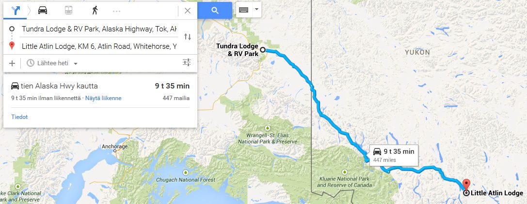
I pulled off the highway at Little Atlin Lake, I'd seen a small lodge there on the map and it looked far enough out of the way for no one to follow me. It's about 10 minutes out of the way, and the way some of these idiots pushed on through Tok yesterday has made he pretty certain no one wants to drop that much time.
Maybe I'll get some privacy tonight.
Anthony Byrne wrote:Once again, we had plenty of company for our second overnight stay, but this time some of the other teams had chosen different places to sleep. One team was 200 miles away in Fairbanks, another was over 40 miles down the road in Dot Lake. We never did get to see that team after the start. We set off again into the cold wilderness. Today, we would make our dash for the Canadian border. We got across without any trouble. Like before, we were treated to some great scenery, beautiful rivers and lakes and more of the towering Rockies. We eventually reached Whitehorse, the first actual piece of civilization we got to see since Fairbanks. After stopping for supplies there we continued on our way, down along the tree-lined shore of Marsh Lake. The trees were lined up side-by-side for miles beyond the horizon. Eventually, we came to our destination - the town of Marsh Lake, where we would be staying the night and planning the next day's trip.

HawkAussie wrote:I might join in
Day 1: Deadhorse to Coldfoot Camp
Day 2: Coldfoot Camp to Tundra Lodge & RV Park
Day 3: Tundra Lodge & RV Park to Westmark Whitehorse Hotel
Total distance: 1082 miles
Total Time: 25h 01m
Alvaro Mazzacane wrote:This day didn't start well. While everyone else started leg 2, we were stuck at Coldfoot with a flat tyre. Thankfully, we had brought a spare tyre, so we weren't stuck in the middle of Alaska. A wheel change later, we were finally underway.
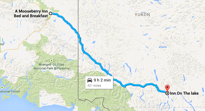
Thiago was driving today, and since navigation is really easy when there aren't any roads to choose from, I had plenty of time to watch the Alaskan landscape. Like everyone else, we were heading for Fairbanks. It is just a small town, but after the lonely Alaskan interior, it seemed like a metropolis to us. But since we still had a lot of driving time left, we didn't stop in Fairbanks. Like the majority of our competitors, we headed southwest towards the Canadian border. We knew that we wouldn't reach Canada yet today, and had planned to stay at the Mooseberry Inn in Tok. But time was running out. With only a few minutes left, we entered Tok, but couldn't make it to the Mooseberry Inn, so we had to stay at the Tundra Lodge, which would cost us about five minutes compared to our competitors.
Alvaro Mazzacane wrote:It was my turn to drive again today. Like everyone else we would head for Whitehorse. But the drive to Whitehorse would take just 9 hours. Surely there must be a better option than staying in Whitehorse. And there was. Thiago discovered the Little Atlin Lodge, and if everything went according to plan, we should easily make it there within 10 hours.
pasta_maldonado wrote:The stewards have recommended that Alan Jones learns to drive.
Nathan Nurmester wrote:Day 3. After going southeast for nearly 10 hours from that damn crowded RV park, we come to a small, remote resort we thought no-one else knew about, but turns out that some Argentineans and Australians have already found it as well. Nikolai's vodka bottle is popular among the other competitors.

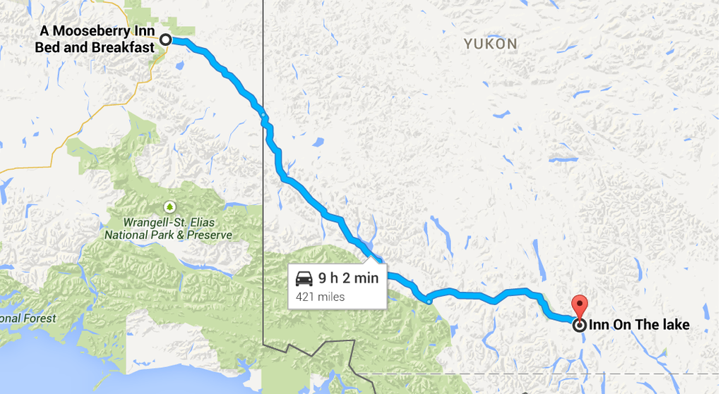
Day 3 begins terribly when its discovered that we have a flat tyre, that delays our departure for about 10 minutes, today sees us cross our first international border into Canada and the territory of Yukon, still travelling along the Alaska highway, why its called that even though we are in Canada is beyond me. Our route takes us past the highest mountain in Canada Mt Logan as we head towards Yukon's capital Whitehorse which according to Guinness world records is the least air polluted place in the world, at least it was until our convoy rolled into town. We have no need to stop in Whitehorse so press on eventually finding the Inn on the lake, which as the name implies is an Inn overlooking Marsh Lake, although there are a few over places to stay around the area this one is just of the main road. Like the 2 previous nights several other teams seem to be stopping the same place. Maybe the organizers should have hired a coach
Thomas De Bock wrote:Prudhoe Bay - Ushuaia Challenge - day 3: Tok to Johnsons Crossing
Once again, many of us were in the same place, just outside Tok, but there were less of us, as some fell behind and only reached the RV park three minutes up the road. We had a slight advantage, but we weren't kidding ourselves, as just a few hundred metres wouldn't make the difference over such a large distance. The true race began in Mexico, we seemed to agree. Either way, any slight advantage was something gained, and we searched for every minute and every kilometre. In this quest, Y'all and I made a brilliant discovery thanks to some tourist maps found on the Internet...
We all left the B&B at the same time, as always, and headed down the Alaska Highway, still the only road that made sense. We soon reached the "centre" of Tok, which was where Alaska Route 1 headed South towards Anchorage and Valdez. We kept going straight ahead on Route 2, the Alaska Highway. Soon thereafter, we crossed the Tanana River and reached Tetlin Junction, little more than a house and an intersection where Alaska Route 5 headed North towards Eagle. We kept going due South East, the only signs of civilisation being old stretches of road that have since been bypassed by the "new" highway.
We eventually reached the small community of Northway Junction, population: 72, with what we thought was the Tanana (actually the Chisana) in the background. Another hour or two later, we reached the border. Went through customs. We were in Canada. Land of healthcare and maple syrup and the Arrogant Worms. The Last Saskatchewan Pirate was blaring on our CD-assisted radio. We attacked the new country with open arms. Whitehorse was getting closer.
Soon enough, we reached another outpost of mankind: Beaver Creek, Yukon (for that was the territory we'd reached). We were on Yukon Highway 1. As the climate got progressively warmer, we saw just as many settlements (they can't be described as village). Koidern was the first. Then, an airstrip announced the arrival of a bigger place: Burwash Landing, administrative centre of the Kluane First Nation. Signs announced more settlements like Destruction Bay as we drove along Kluane Lake. We left the lake soon thereafter and stumbled upon Bear Creek, then, a few minutes later, undoubtedly the third-largest place we'd come across (after Fairbanks and Tok): Haines Junction. As its name confirmed, it was where Yukon Highway 3 turned South and headed towards Haines, Alaska. This wasn't interesting and led to a dead end, or worse: Juneau.
Instead of turning South, we headed straight East towards the capital: Whitehorse. Firstly, we passed Mendenhall Landing, then Ibex Valley, Takhini, then the suburbs of Crestview and Porter Creek and finally Whitehorse, definitely bigger than Tok. This was where we expected other teams to start stopping. One team left the highway there and then, but the rest of us carried on. At Carcross Cutoff, Yukon Highway 2 turned South, but would rejoin a while later. We passed Marsh Lake to our right, then Highway 8 rejoined, and teams started going mad. Some had already stopped at an inn on Marsh Lake. Everyone else left Highway 1 and scramblde into the side roads. We checked our clock. According to our calculations, we would barely make our destination.
For we had found a place Google Maps did not foresee. A few miles down the road, past Squanga Lake Airport, on the Teslin River, an RV park and motel was placed. We reached Johnsons Crossing RV Campground & Motel with a minute to spare. We were comfortably ahead of everyone else, and we could get a good night's sleep.
kevinbotz wrote:Cantonese is a completely nonsensical f*cking alien language masquerading as some grossly bastardised form of Chinese
Gonzo wrote:Wasn't there some sort of communisim in the East part of Germany?
Shadaza wrote:Wow, great move from tommykl there taking a small but obvious lead.
Sorry I won't post much of a summary today. Most teams are in or around Whitehorse, Leg 4 is open and I predict that we might see a few variations in route. Good luck and safe travels everyone.
Let me know if you wish to have access to the world map overlay screen. I won't always have time to update it and any volunteers would be greatly appreciated.
Well, we managed to stay alone for about 3 days, we got some company from other squads. But thankfully it wasn't that Mike guy. Lot of teams turned out to rest at a hotel close by, only one team progressed beyond. It was a crappy VW Golf with a Belgian licence plate. Yeah, dad talked a lot about how they were tactically outsmarted by Erik and John in the famous asia race! Of course, those Walloons feel at home here in the middle of nowhere, it's where civilisation starts that we Flemish will make the difference. And no mom, i don't mean you dancing Flamenco! They don't do that dance in Latin America! Besides, you can't dance! And no, you being Italian does not make you latin!
Thankfully the teams we shared our hotel with turned out to be nice enough. That's what mom thought anyway, after a couple of beers, she began flirting with them. Mom, you're married, for heaven's sake!
But so far, still a good rest at night, and waking up to the astonishing Marsh Lake was great. For as far as waking up can be a great thing... But eventuallty, even those lakes are getting tiring. Lakes, rivers, pine trees, rocks.
A little after halfway, we approached the crossing between the 1 and the 37. I suppose some teams will take the 37 and try the western route. We decided to stay on the 1, that turned into the 97 later on.
Signs of civilisations are still rare. Only some bears and truckers.
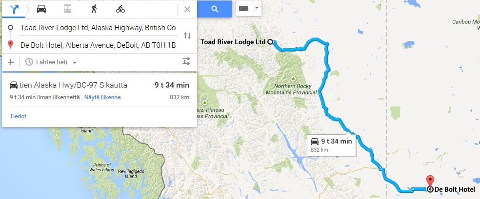
Eventually, we stopped in the village Toad River. Not much of a village, but it has a sleeping place. We wouldn't be able to make it into the next hotel, so this should do. We will probably get some more company tonight.

Rob Dylan wrote:Mercedes paying homage to the other W12 chassis by breaking down 30 minutes in

Biscione wrote:I mean, Renaldo Jimenez, could you ask for a more world class pay driver? Who even is Alexey Buyvolov, amirite?

An old and slightly mad Australian man wrote:Day 4:
I thought I'd have privacy. Nope. Those RTCC idiots clearly followed me to Little Atlin. This time, I figured, I'd leave early and get some quiet on the road.
After about 4 hours, I had a choice. I could continue east on the longer road, or turn south and take a route closer to the coast. I figured most people would go south, leaving the east route hotels emptier. An easy decision.
Nope. Those bloody Belgians who clearly hate all people were there first. Bastards. I briefly considered going on before I decided I didn't care enough and just tried to stay away from them.
The Beginning of Day 4 and again it turns out most of the teams are staying in the Marsh Lake area untill we discovered that the De Bocks had found an RV park further up the round making them an hour ahead. Again a convoy headed along the Alaska Highway however up ahead was a junction two roads both lead towards the the town of Prince George. Route 37 or 97 that was the choice no idea what would be quicker so we decided we would do the opposite of the car in front they took 97 so we took 37. heading into British Colombia we continued our drive south finally coming on a place to say by our calculations we wouldn't make it to the next one so we decided to stop here and it seems some other teams had made the same decision. the question though are we catching those Belgians
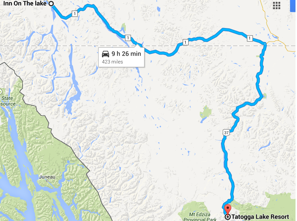
Anthony Byrne wrote:There weren't so many of us staying in the Inn on the Lake. Our options are opening up, so less people are going the same route. We set off again for day four of our grand journey. This time, our target was Fort Nelson, British Columbia, though we didn't anticipate getting there in under ten hours, so we had a lodge in Toad River picked out just in case. We continued along the tree-lined roads of Southern Yukon. We eventually came to a point where the highway followed the shores of Teslin Lake for many miles. It was a beautiful sight on an equally beautiful today. It was getting warmer now too. After that it was more nice, if repetitive, scenery before we simply had to stop in Toad River, and by the looks of it, we weren't the only ones...
Nathan Nurmester wrote:Day 4. After another night sleeping like sardines in a can we had our first big choice to make. We could either turn south on the Stewart-Cassiar Highway and go through the mountains and eventually near the west coast, or keep heading east-southeast on the Alaska Highway to eventually reach the big cities in Alberta. After a coin flip we decided on the latter, and as time went on I found out we were quickly heading into an area with loads of national parks and very little habitation. We eventually had to stop with 45 minutes to spare in the small community of Toad River, as the next accomodation we knew of would've been in Fort Nelson over two hours further down the road. Turns out we were not the only team to come to the same conclusion.
Thomas De Bock wrote:Prudhoe Bay - Ushuaia Challenge - day 4: Johnsons Crossing to Tetsa River
It felt nice to have a lead. But we'd have to keep it. And there was the issue. Still not many hotels around, and other teams could very easily catch up. Looking at the map, we saw Fort Nelson was way too far to make it in ten hours. We'd have to settle for closer. We left the motel at the designated time and rejoined the familiar Alaska Highway, still called Yukon Highway 1. We drove by Johnsons Crossing, where Canol Road (Yukon Highway 6) turned off North, and headed South towards British Columbia.
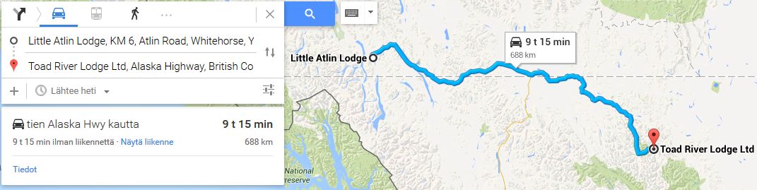
After a while, we reached the village of Teslin, by the homonym River. Soon thereafter, we reached Southern Canada, although it certainly didn't feel like it... Indeed, for all intents and purposes, we were still in Yukon. No roads left the Highway, and we soon shot back North into Yukon. After another couple of hours of nothingness, we faced our first major decision. A bit before Upper Liard, Yukon, we could either continue forwards towards the Canadian Plains and Edmonton, or take Highway 37 Sotuh towards the West Coast and Vancouver. We'd made the decision that morning: we continued East. We found accommodation in Upper Liard, but it was far too early to stop. Soon, we reached Watson Lake, the first place since Whitehorse that we could actually call a town. It even had streetlights! It apparently had a Signpost Forest, but we couldn't stop. A sign told us we could move North on Highway, but that would take us back to Whitehorse. Why would we want that?
The Highway started heading vaguely South again, and we found ourselves in British Columbia once more, confirmed by the road's change to BC Highway 97. Signs then told us that we successively crossed the provincial border six times, passing by the unannounced Iron Creek Lodge along the way. We crossed the border for good, then the Liard River and its well-advertised Hot Springs. We passed the Northern Rockies Lodge in Muncho Lake, then, about half an hour later, the community of Toad Lake. Checking the clock, we expected most teams taking the plains route to stop there. We still had enough time to reach our planned stop.
About an hour down the road, we reached the Tetsa River Lodge, an hour and a half outside Fort Nelson. We had half an hour to spare, but there was no other option. Having spotted no accommodation after the Toad River Lodge, we were content with our lead.
kevinbotz wrote:Cantonese is a completely nonsensical f*cking alien language masquerading as some grossly bastardised form of Chinese
Gonzo wrote:Wasn't there some sort of communisim in the East part of Germany?

Novitopoli wrote:Everytime someone orders at Pizza Hut, an Italian dies.
Novitopoli wrote:Juve's Triplete: Calciopoli, doping & Mafia connections.

Anthony Byrne wrote:Three Canadian territories and provinces in three days. All in a little 50-year-old VW Beetle driven by two lads from old Ireland. What a tale this was turning out to be. Although the slowly dwindling pack we were still a part of no longer held the lead. We'd found that the De Bocks were able to make it as far as Tetsa River Lodge, somewhere we'd looked at but figured it was impossible to reach in ten hours from Marsh Lake. Obviously, they were staying somewhere that little bit closer. We shared our accommodations with three other teams: Professional racing drivers Nathan Nurmester and Nikolai Nurmovich, the other Belgian team from the night before and a slightly mad Australian man who seemed to be avoiding the rest of us as much as possible.
As we set off for day 5 of our who-knows-how-long trek, we noticed another car pulling out from a B&B we were previously unaware of. It was those two guys who went straight on at Coldfoot! I beeped the horn and quickly overtook them, never looking back to see how they reacted. Now, it was a matter of catching up with the De Bocks in our little Bug. We passed more towns as we headed for the border with Alberta. Actual towns, not little hamlets of about twenty people. Tomorrow our route should take us through Edmonton and Calgary. Tonight though, we sleep in Grande Prairie, in a little motel just off the highway.

Biscione wrote:I mean, Renaldo Jimenez, could you ask for a more world class pay driver? Who even is Alexey Buyvolov, amirite?
Jeremy-Etienne Voeckler wrote:Eh Freddy...apparently we're equal first now! Gun it! It's us versus the De Bocks!
Frederic-Maxime Voeckler wrote:Calm down J, this isn't the 80s anymore! We're in a Renault Trafic not a Renault F1 car. If I go any faster I will roll the van into a river!!
Novitopoli wrote:Everytime someone orders at Pizza Hut, an Italian dies.
Novitopoli wrote:Juve's Triplete: Calciopoli, doping & Mafia connections.
Uuugh, i had rough sleep. Apparently half of the field slept in the same hotel, or at least were supposed to sleep. Damn, did some of them snore, it was like sleeping in the same room with a world war 2 airplane!
No mom, i haven't actually slept with a world war 2 airplane! It was a metaphor! Why would i sleep with an airplane? And were you flirting with those guys again? Don't make friends with the enemy!
Altough most of our conversations were about that one guy that claimed he saw a car passing with a Voeckler sticker on it. I'm sure he's been taking drugs. I's impossible those guys would even make the Canadian border!
Well, the road initially wasn't that different. And yes mom, i had to stop for those crossing ducks! I mean, they were sooooooooooo cute! As we progressed, the roads became less curvy, and we approached a village. Wow, i thought people were extinct here in Canada, but there you go! People!
But after we passed trough this village, it was all the same. Except that this time the roads were a little faster, and sometimes even houses and roads appeared! Wowzie! It continued until we got to Fort St. John. Apparently Cananadians like their fortsies! And short after that, another village! Dawson's Creek... wasn't that a boring tv series? I always thought Wembley was situated in England, uncle Ron has mentioned about that i think, but apparently he was wrong, it's near Grande Prairie. I suppose Captain Obvious named this village.
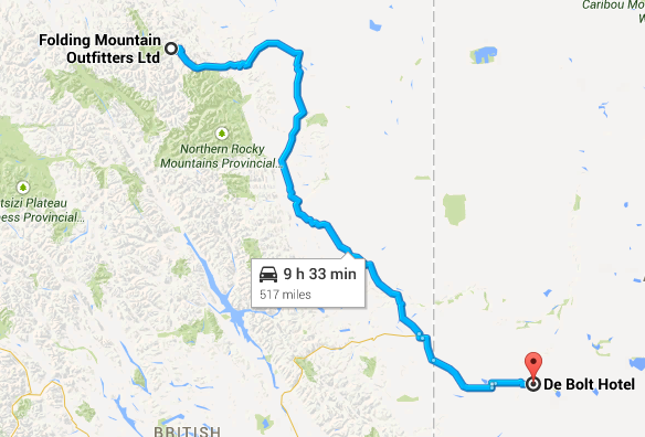
We had less than an hour to go, but decided to continue direction Valleyview, and stopped in an inn named De Bolt Hotel. Anyway, today was productive as we did over 800 km. We expect to make it to the border tomorrow.
Now time to take a bath. And waaaaaaaaaaaah, oh my god, a naked man. *hits him in the balls*


An old and slightly mad Australian man wrote:Day 5:
I can get no privacy. These people insist on following me from hotel to hotel. My carefully thought out and unique route has turned out to not be unique at all.
Nearly everyone stopped at Toad River. Thankfully the idiots who missed Coldfoot kept going on. It was entertaining when the Irish blokes in the Beetle blasted them with their horn this morning. They nearly drove into a tree in panic.
I ended today at the De Bolt Hotel, and the Belgians were already here. My plans have me cut south at Edmonton, but I may be tempted to keep going east if the others turn off. I'll have to prepare a contingency plan.
Rob Dylan wrote:Mercedes paying homage to the other W12 chassis by breaking down 30 minutes in
Day 5 and it seems that only one other team took the same route as me those 2 Australian kids another day driving through remote Canada our target was Prince George however it just to far away we end up staying just outside of Vanderhoof and for the first time we are all alone not sure what happened to the kids. the good news tomorrow all going to plan we should re-enter the United States
Thomas De Bock wrote:Prudhoe Bay - Ushuaia Challenge - day 5: Tetsa River to Fox Creek
We had a larger lead than before. Or at least we thought we did. Suddenly, out of nowhere, the Voeckler brothers arrived. F-M and J-E seemed surprised to see us. We were even more bemused than they were. We quickly learned that they'd arrived late in Deadhorse and had powered through the wilderness to reach Tetsa River. We weren't the only ones to have found the crucial Johnsons Crossing Campground. After returning to our rooms, a few "merdes", "bordels" and "putains" later, we got ready for leg 5, which we would start alongside the French. Urgh.
We left the Tetsa River Lodge at the same time we were supposed to, with the Voecklers leaving just ahead of us. We would very likely end up in the same place, which would only increase the weirdness. We were hoping for a miracle that would allow to reach Edmonton in ten hours, but we soon realised it was never going to happen. After an hour and a half, we reached Fort Nelson, right behind the Frenchmen. We crossed the Muskwa River and headed South. We thought settlements would become more frequent, but no. Not yet.
We passed Prophet River another couple of hours down the line. Another while later, we reached Buckhinghorse River. "The Last Saskatchewan Pirate" wasn't a good analogy for our experience of Canada thus far. It was better described as "Rocks and Trees". As it turned out, Canada does have a lot of them. We did end up spotting more and more outposts of mankind, such as the Sasquatch Crossing Lodge. Then, Pink Mountain. Then Wonowon. Then Buick. Then Montney. Then, finally, the larger settlement of Charlie Lake. And immediately afterwards, the comparatively gigantic city of Fort St. John. We hadn't seen anything this big since Whitehorse. And we'd have to keep going.
We crossed the well-maintained suburb of Taylor, then back into what we were comfortably calling "the countryside". It wasn't the wilderness anymore. We were far South enough to call it that. Then came the vaguely-defined Farmington and Arras, then finally, Dawson Creek. Its baseball fields. Its footballs pitches. Its dirt oval. We couldn't stop there either, it was far too early, but we crossed a milestone. In the centre of the city, the Alaska Highway ended. We'd known only that road for days. We had two choices. The first was to head East on Spirit River Highway (B.C. Highway 49) and head towards Winnipeg, or the Tupper Highway (B.C. Highway 2) South-East towards Edmonton.
We choes the latter, and so did the Voecklers. We drove through the village of Pouce Coupe (French? In British Columbia?), then Tomslake, then (I'm told) Tupper, where Highway 52 looped back towards Arras. We kept going into Alberta, where the Highway became Alberta Highway 43. The first sign we saw read "Demmitt". Then, a while later, Highway 59 led East towards Sexsmith, Alberta. Oh, Canada...
We drove through the village of Hythe, which had a racetrack for no apparent reason, before reaching Beaverlodge. Minor provincial highways branched off towards other major highways and range roads. The road branched into a dual carriageway, signaling the start of serious business. Various signs announced the towns of Wembley, Clairmont and Grovedale before we finally reached Grande Prairie, population of over 50 thousand people. Again, we faced two choices: head South on Highway 40, meandering slowly towards Calgary, or continue East then South towards Edmonton. Again, both of us picked the same route: to Edmonton, still on Highway 43.
While more highways branched off, North and South, we bypassed Bezanson with a now rare curve. We passed the small hamlet of DeBolt, where we thought most teams would stop (Valleyview would be out of reach for them), and continued towards the rather sprawled-out Calais, Alberta (more French?), after which we turned South past Valleyview. We still had time to reach our destination: Fox Creek, Alberta.
There were three hotels to choose from, but both the Voecklers and ourselves chose the most convenient one: the Comfort Inn & Suites, which does indeed deserve its name. We just hoped we wouldn't be stuck with the Voecklers until Colon...
kevinbotz wrote:Cantonese is a completely nonsensical f*cking alien language masquerading as some grossly bastardised form of Chinese
Gonzo wrote:Wasn't there some sort of communisim in the East part of Germany?
Nathan Nurmester wrote:Day 5. We seem to have the exact same plans as quite a few other teams. Not only did we start from the same location, we're also finishing in the same spot where at least three teams have also pulled over for the night. At least this time there should be enough rooms so that we don't need to sleep on couches and carpets.
peteroli34 wrote:Day 5 and it seems that only one other team took the same route as me those 2 Australian kids another day driving through remote Canada our target was Prince George however it just to far away we end up staying just outside of Vanderhoof and for the first time we are all alone not sure what happened to the kids. the good news tomorrow all going to plan we should re-enter the United States

Biscione wrote:I mean, Renaldo Jimenez, could you ask for a more world class pay driver? Who even is Alexey Buyvolov, amirite?
Yesterday, we were one of the first to get up (despite moms complex make-up and dress morning routine) But that came to a prize: everyone was following us. Well, at least this hotel was a bit more spacy, and we actually got to meet other visitors.
When it comes to traveling, initially still the same boring routine from the first days. The first signicant place we passed was Whitecourt. After that still only some minor cities and villages. And then, suddenly: Edmonton! A real city! It was tempting to go to the centre and just go shopping! But after much debate, we pulled ourselves together, and decided that Calgary would also be a good place to go shopping! Somehow we missed the exit to the centre of Calgary and kept heading south. It's probably for the best. After nine long hours, there was finally some excitement! A border! Another ridiculously straight border line. Talking about borderline, it was confirmed the Voecklers really did overtake us and the De Bocks didn't get much sleep.
So eventually we entered the state of Montana. I guess you could say we came in like a wrecking ball! Sorry, i promise not to do that ever again. Turned out we were in the Blackfeet Indian Reservate. We called it a day in the town of South Browning and headed for our Wigwam. Just kidding, we're in an actual hotel! I think the leading teams should be somewhere around Great Falls or Seattle. Nothing too problematic, i think. On a positive note, today we traveled more than 1000 km's!
And to those other teams: i understand that you sleep in the same hotel, but if i catch one of you guys peeking trough my window again, i swear i'm calling the police! Except for those two girls, they can peek at me any time if they want to ^^

Anthony Byrne wrote:Staying in Grande Prairie was a mistake. Other teams that we'd stayed with the night before pressed on. It turns out there was another place we could have stayed in DeBolt. I was very angry at Eoin. He's sacked now, or at least he would be if he wasn't my friend, so all he got was a good shouting. Our route took us further east, through DeBolt (I glared at Eoin when we passed through), past the beautiful Sturgeon Lake (which apparently does not have any sturgeon) and through Valleyview before turning south towards Edmonton. We were passing towns with more frequency and no longer felt as isolated as we were in Alaska. Our spirits had certainly picked up. We passed through Edmonton and Calgary as we pushed towards the border. We had vowed that we would cross the border today, but things weren't looking so smooth. We reached the border checkpoint with ten minutes left on the clock and were held up for what seemed an eternity, just hundreds of metres from where we would be staying on the other side. By the time we got through it was just three minutes. It was Tok all over again as I pushed hard on the accelerator as I guided the Beetle towards the next freeway exit, making it to the Glocca Morra Inn and stopping the clock at exactly ten hours. I couldn't believe it. We'd only barely made it back into the United States.


